Description
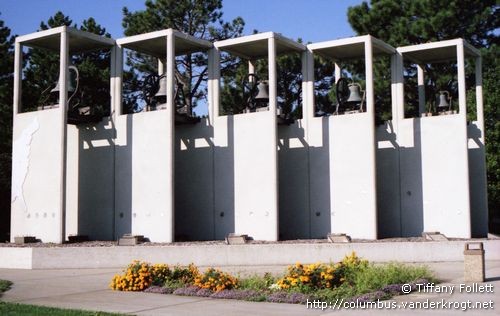
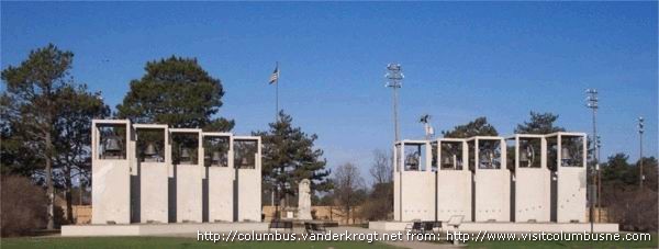
This unique monument to Columbus' first voyage to the New World is made from 10 large bells that peal every 15 minutes. The photo shows the left wing with five towers. The Google Earth image shows the lay-out (not very clear).
Inscription(s)
A plaque shows a world map, with the route between Europe and America depicted by the bell towers. Beneath this the text

The interconnecting walls in which the bells are
displayed are arranged in a stepped back setting to
create a visual transparency through the structure.
Superimposed within this structure is a map representing
Christopher Columbus' first journey to the New World.
The front right panel begins his trip from Spain
on August 3, 1492. The next eight panels represent
the route he took, and the front left panel indicates his
final destination, North America, on October 12, 1492.
In Memory of Mr. and Mrs. E.M. Nielsen, Sr.
Annotation
The belltowers monument was officially dedicated April 25, 1992, after over two years of planning and construction. The belltower was conceived as a lasting monument to the 500th anniversarty of Columbus' first voyage to the new world. The project was made a reality initially by the donation of ten bells from the collection of Leonard Fleischer. Each of the bells has a historical significance and a plaque near each tower tells that bell's history.
Dunham's design explanation states "the first goal was to create an aesthetically pleasing structure for the display of the various bells chosen for the project. The second goal was to have the structure symbolize Columbus' expedition to the New World, by graphically illustrating this journey.
N.B. The statue, visible through the "gap" between the two wings is the statue of the Prairie Pioneer from 1927.
Sources & Information
- Barb Grachek, director of the Columbus Area Chamber of Commerce, sent me a photograph and the information leaflet.
- Photo: Tiffany Follett, 16 September 2006. See Tiffibunny's photostream on Flickr.
- Visit Columbus, NE, Places to see.
Tags
Locatie (N 41°25'21" - W 97°22'6") (Satellite view: Google Maps)
Item Code: usne01;
Added: 29 December 2006
© Website: René & Peter van der Krogt

Your banner here? Click for information.